§ 91.103 Preflight action. Each pilot in command shall, before beginning a flight, become familiar with all available information concerning that flight. This information must include— (a) For a flight under IFR or a flight not in the vicinity of an airport, weather reports and forecasts, fuel requirements, alternatives available if the planned flight cannot be completed, and any known traffic delays of which the pilot in command has been advised by ATC;
Source: 14 CFR 91.103, eCFR
You are training to be that pilot in command. The habit is not learned overnight, so it starts on day one, at home, on your phone, not in the car on the way to the field.
Why your phone forecast is good for about three days
The weather app on your phone is a real forecast from the same models the aviation forecasters use, and it is honest about its limits if you know where to look. NOAA puts it this way.
A seven-day forecast can accurately predict the weather about 80 percent of the time and a five-day forecast can accurately predict the weather approximately 90 percent of the time. However, a 10-day—or longer—forecast is only right about half the time.
Source: NOAA NESDIS, How Reliable Are Weather Forecasts?
I tell students three days, not five, because "right" for a phone app means the high temperature and a rain chance. A lesson needs the ceiling, the visibility and the wind at 3 pm, and that level of detail does not survive five days. Forecasts get roughly one more day of useful reach every ten years (Bauer, Thorpe and Brunet, Nature, 2015), so this number will creep up over your flying life, but for now, three.
The picture everyone already knows is the hurricane cone. Five days out, the National Hurricane Center draws a circle 200 nautical miles wide around where the storm will be, and the cone covers several states. Three days out that circle is 95 nautical miles. Twenty-four hours out it is 39, about the width of two counties. The cone is built so that two-thirds of past forecast errors fall inside it, which is why it narrows instead of vanishing: the forecast never becomes certain, it becomes small enough to act on. Your lesson works the same way. Three days out you know whether the week is a front or a high. The night before you know the hour. Two hours before you know.
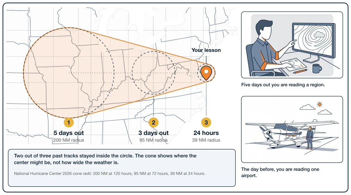
The size of each circle is set so that two-thirds of historical official forecast errors over a 5-year sample fall within the circle.
Source: NOAA National Hurricane Center, Definition of the NHC Track Forecast Cone
What a TAF is, and who gets one
A TAF is a forecast for one airport, written by a National Weather Service forecaster, in the same code as the METAR you will learn to read at the same time. It covers the air within five statute miles of the runways, and nothing beyond that. New ones come out four times a day, at 00Z, 06Z, 12Z and 18Z, and when the weather stops matching the forecast the office issues an amendment rather than waiting for the next cycle.
Terminal Aerodrome Forecasts (TAF) are prepared by 123 NWS Weather Forecast Offices (WFOs) for over 700 airports. These forecasts are valid for 24 or 30 hours and amended as required.
Source: FAA Aeronautical Information Manual, 7-1-3
Over 700 airports sounds like a lot until you look for yours. Republic Airport (KFRG), where most of my students fly, does not have a TAF. Neither does Essex County (KCDW) or Morristown (KMMU). You use the nearest airport that does, and you keep in mind that it is a forecast for that field, five miles around it, not for yours. The New York area list is at the end of this guide. For a Republic lesson the closest TAFs are Long Island MacArthur (KISP) and Kennedy (KJFK), and every example below uses KISP for exactly that reason.
Most TAFs run 24 hours. A short list of airports the FAA names get 30-hour TAFs, and in our area that list is Kennedy, LaGuardia, Newark, Teterboro and Stewart. That extra six hours matters more than it sounds, and the time section explains why.
Here is the airline reference I give every student. The longest nonstop flights a US airline runs are about 17 hours (United's San Francisco to Singapore is 17 hours 40 minutes), and the rule that caps airline flight time stops at 17 hours with four pilots aboard. A 24-hour TAF is longer than the longest flight I will ever fly. It is certainly longer than your two-hour lesson.
(2) Will exceed 13 hours if the operation is conducted with a 3-pilot flightcrew. (3) Will exceed 17 hours if the operation is conducted with a 4-pilot flightcrew.
Source: 14 CFR 117.11(a), eCFR
Why everything is in UTC, and how to convert it both ways
Every TAF, every METAR and every clearance from air traffic control is in Coordinated Universal Time, which pilots call Zulu or just Z. The reason is the airplane I fly at work. A flight from New York to Los Angeles crosses three time zones, so the release the dispatcher hands me prints every time in UTC, and I write the local time next to it myself. The airplane's clock stays on Zulu. The weather arrives in Zulu. ATC gives me a time in Zulu. If the whole system used local time, a forecast for "3 pm" would mean something different at each end of one flight.
FAA uses Coordinated Universal Time (UTC) for all operations. The word "local" or the time zone equivalent must be used to denote local when local time is given during radio and telephone communications. The term "Zulu" may be used to denote UTC.
Source: FAA Aeronautical Information Manual, 4-2-12
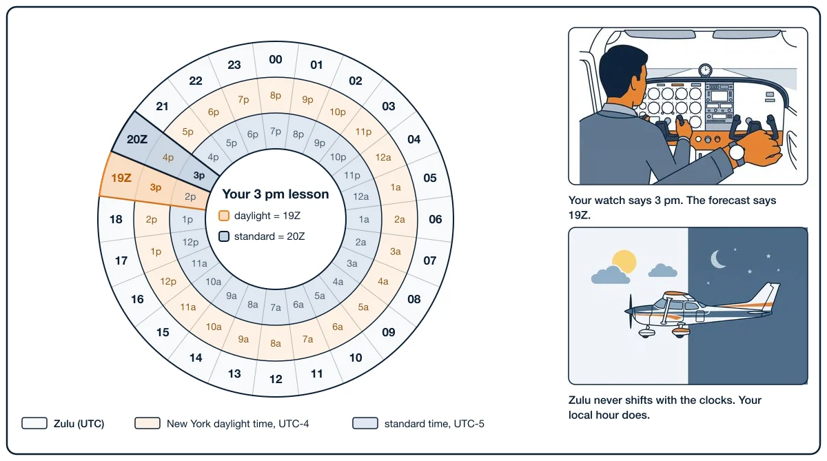
A training airplane's clock is usually on local time, and your lesson is booked in local time, so you convert. New York is four hours behind UTC in daylight time (March 8 to November 1 in 2026) and five hours behind in standard time.
Local to Zulu. Add four in summer, five in winter. A 3 pm lesson is 15:00 local. In July that is 15:00 + 4 = 19:00Z. In January it is 15:00 + 5 = 20:00Z. Past 8 pm in summer you cross midnight Zulu: a 9 pm local time is 01Z on the next date, which is why a TAF line can carry tomorrow's date while you are still eating dinner today.
Zulu to local. Subtract the same number. A TAF group that begins FM1900 starts at 19:00Z, which is 3 pm in July and 2 pm in January. If the Zulu hour is smaller than four, you are on the previous local date: FM0200 is 10 pm the evening before in summer.
Try both directions below, then do the second half: enter the lesson as a block, not a moment. A 3 pm lesson runs to 5 pm, and the weather that matters is the weather arriving during it and the weather leaving after it. The timeline shows which forecast group is in force before, during and after your block.
Lesson clock: New York ↔ Zulu
Lesson: 2026-07-18 19:00Z to 2026-07-18 21:00Z. Zulu date: same date.
TAF issued 2026-07-18 11:40Z. Valid 2026-07-18 12:00Z to 2026-07-19 12:00Z.
Outlined region: lesson block
- Base — before:
21006KT P6SM FEW050 - FM181800 — during:
22009KT P6SM SCT060 - FM190100 — after:
20005KT P6SM SKC
The four things to read
A whole TAF is a wall of code. A student pilot reads four things in it, and only inside the block the lesson occupies.
Wind
22009KT is a wind from 220 degrees true at 9 knots. 29018G26KT is from 290 at 18 knots, gusting 26. The direction is where the wind comes from. That is the part people get backwards, because everything else in aviation is about where you are going: the runway number is the direction you roll, a heading is the direction you fly. Wind is the exception. A wind from 220 is blowing toward 040, so on runway 19 at Republic it is 30 degrees off your nose, mostly a headwind, which is what you want. Why you want it is the next section.
Visibility
P6SM means more than six statute miles, the best a TAF will say. 4SM -SHRA is four miles in light rain showers, and 2SM TSRA is two miles in a thunderstorm with rain. Legal VFR near the airport is three miles. A student lesson wants five or better.
Sky cover
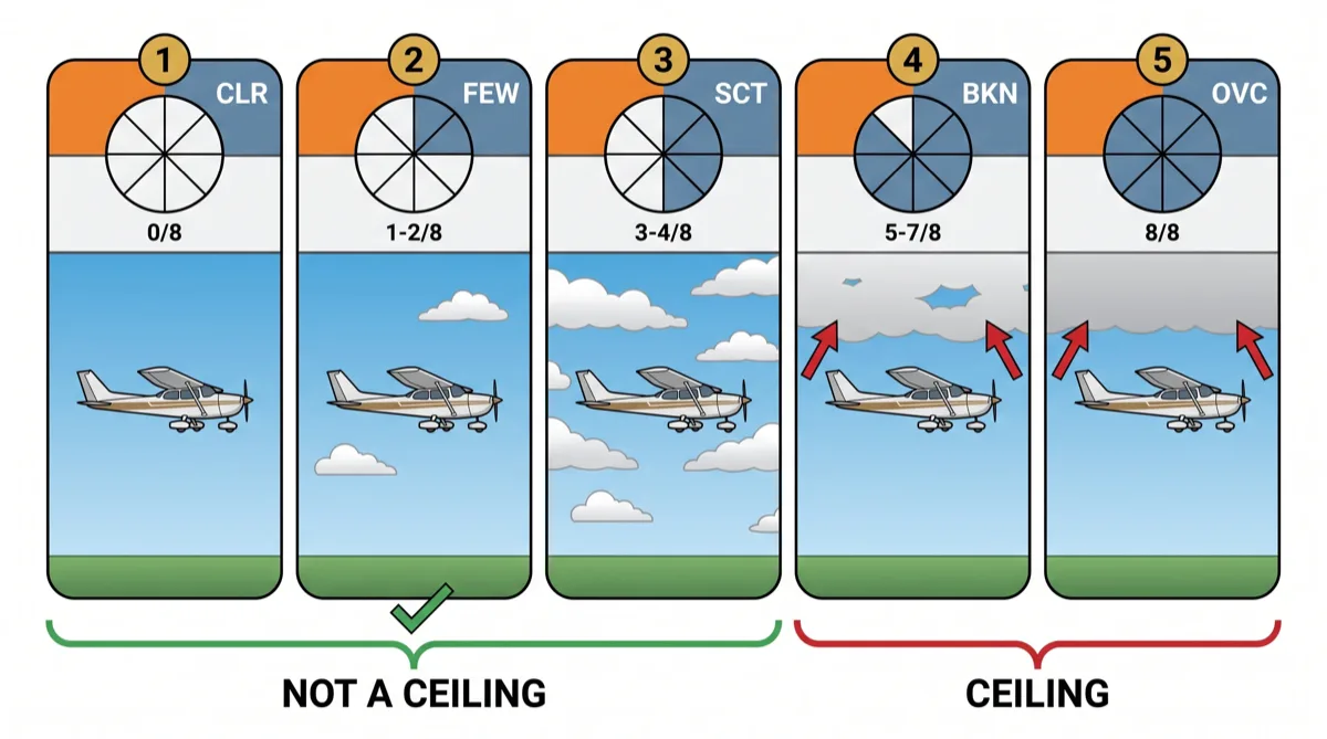
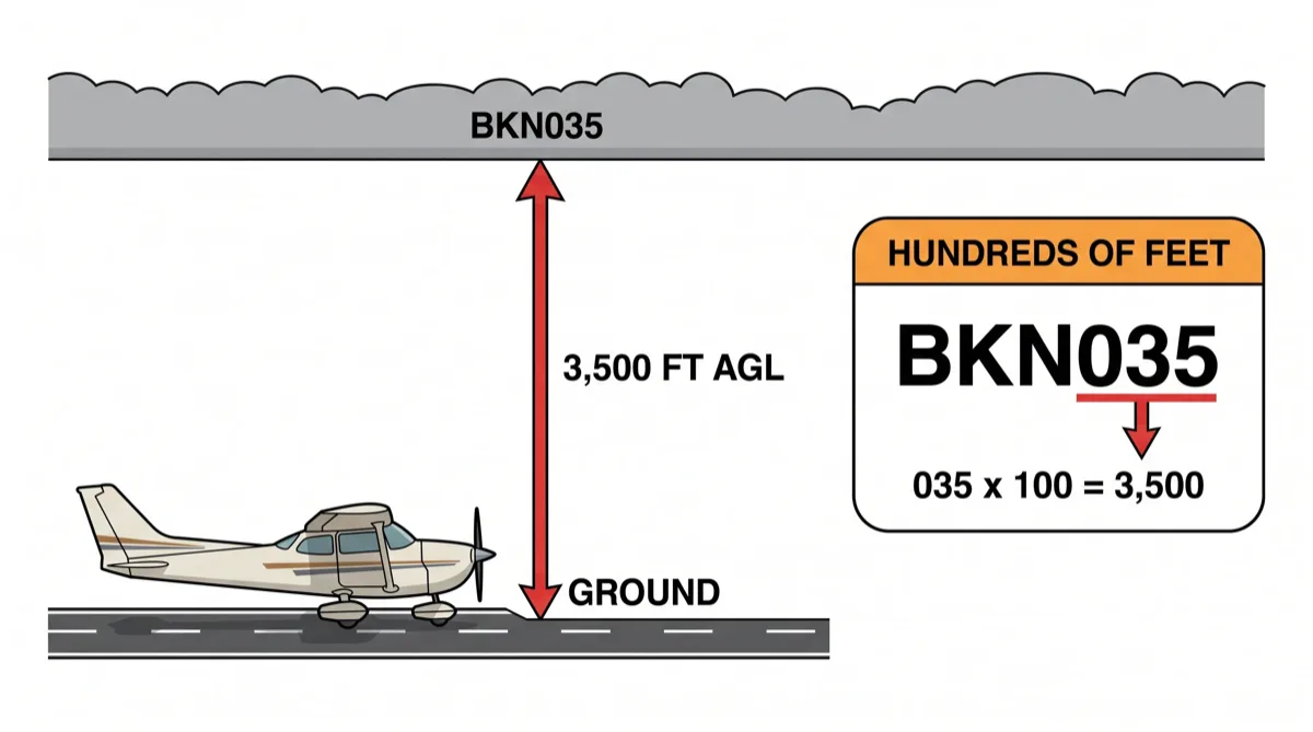
Clouds are reported in eighths of the sky, and the height is in hundreds of feet above the ground. SCT060 is scattered at 6,000 feet. BKN012 is broken at 1,200 feet. OVC015CB is overcast at 1,500 with cumulonimbus, which is a thunderstorm cloud.
SKC clear (no clouds) FEW >0 to 2/8 SCT scattered (3/8s to 4/8s of clouds) BKN broken (5/8s to 7/8s of clouds) OVC overcast (8/8s clouds)
Source: FAA Aeronautical Information Manual, 7-1-11
The word that matters is ceiling. A ceiling is the lowest broken or overcast layer. Few and scattered clouds are not a ceiling; you can fly under, around and above them. Broken and overcast are a lid. SCT040 BKN050 gives you a 5,000 foot ceiling, and a 5,000 foot ceiling is what I want over a student.
| Code | Eighths of sky covered | Is it a ceiling? | Example | Plain reading |
|---|---|---|---|---|
| SKC or CLR | 0 | No | CLR | Nothing below 12,000 feet at an automated station |
| FEW | 1 to 2 | No | FEW050 | A few clouds at 5,000 feet |
| SCT | 3 to 4 | No | SCT060 | Scattered at 6,000 feet |
| BKN | 5 to 7 | Yes | BKN012 | Broken at 1,200 feet, ceiling 1,200 |
| OVC | 8 | Yes | OVC015CB | Overcast at 1,500 feet with thunderstorm cloud, ceiling 1,500 |
Change groups
The first line of a TAF is the starting weather. Everything after it says how the weather changes, and this is where students lose the thread.
FM181800means "from the 18th at 18:00Z" the weather becomes this, and it stays that way until the next group. A hard switch.BECMG 1820/1822means the change happens gradually between 20Z and 22Z on the 18th. By 22Z the new weather is in.TEMPO 1819/1822means temporary conditions, lasting less than an hour at a time, somewhere between 19Z and 22Z. The base forecast is still the base; this is the dip you might hit.PROB30 1818/1822means a 30 percent chance of these conditions between 18Z and 22Z. For a student, a 30 percent chance of a thunderstorm is not a coin flip you take.
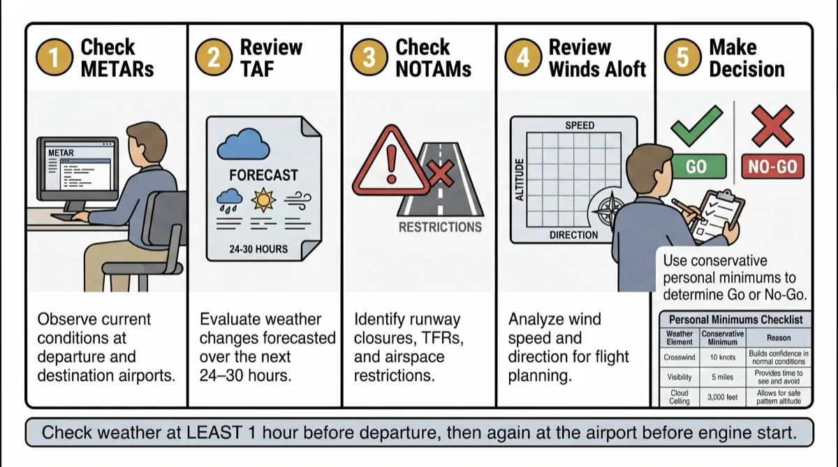
Why we take off into the wind
An airplane's wing makes lift from air moving over it. It does not care whether the airplane is moving through the air or the air is moving over the airplane. Sitting at the end of the runway you have no speed and no altitude, which means you have no energy to work with, and every knot of wind blowing down the runway at you is a knot of airspeed you got for free. That is the whole reason for choosing a runway: point the nose at where the wind is coming from.
Once you are moving, think of speed and altitude as the two pans of a balance. Lots of speed at low altitude? Raise the nose and trade it: you slow down and you climb. Lots of altitude? Lower the nose and trade the other way: you descend and you speed up. Both pans together are the energy you have, and an airplane moving through air is always paying a tax on it, called drag. The engine's only job is to pay that tax and, when you ask, to add to the total. Try the balance below, then switch the engine off and watch what drag does to the total.
Speed, altitude, and energy
Trade speed for altitude without changing the total. Drag removes energy; the engine adds it. These are teaching units, not flight performance numbers.
Total energy: 100.0. Engine off.
Each pan holds 0–100 units. Every two seconds: engine off removes 1 unit; engine on adds 2 units, up to the 200-unit capacity.
The crosswind is the part of the wind that is not on your nose, and it is its own skill with its own numbers. The crosswind component guide has the chart, the calculator and the runway math; this guide only needs you to read the wind line and know which runway it points at.
The habit: three checkpoints
The whole method is three looks at the weather, each one shorter and more specific than the last.
| When | What you read | What you can know | What you do |
|---|---|---|---|
| Three days out | The weather app on your phone | Whether a front, a storm system or a windy day is headed for lesson day | Nothing yet, except paying attention |
| The night before, after 8 pm | The nearest TAF, the issue that reaches your lesson hour | Ceiling, wind, visibility and change groups across your block | If it is clearly a no, reschedule now and free the slot |
| Two hours before | The current METAR plus any amended TAF | Whether the forecast is coming true | Go, or make the call your instructor would make anyway |
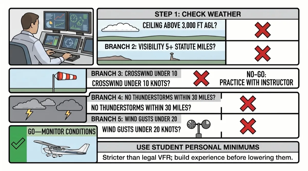
For a student on a visual-flight-rules lesson, these are the gates I use, and they are bare minimums, not targets: a ceiling of 5,000 feet or higher, visibility of five miles or better, a crosswind component under 10 knots, and no rain, snow or thunderstorm in the block. The FAA's legal minimums are lower.
Class E: Less than 10,000 feet MSL 3 statute miles 500 feet below. 1,000 feet above. 2,000 feet horizontal.
Source: 14 CFR 91.155, eCFR
Legal is the floor for a licensed pilot on a good day. A lesson is for learning, and you learn nothing on final while fighting a gust you had no business being in.
The 5,000 foot gate is ours, not the FAA's, and here is where it comes from. Slow flight and both stalls on the private checkride have to finish above a floor the Airman Certification Standards set by aircraft category:
Select an entry altitude that allows the Task to be completed no lower than 1,500 feet above ground level (AGL) (ASEL, ASES) or 3,000 feet AGL (AMEL, AMES).
Source: FAA-S-ACS-6C, PA.VII.A/B/C.S2
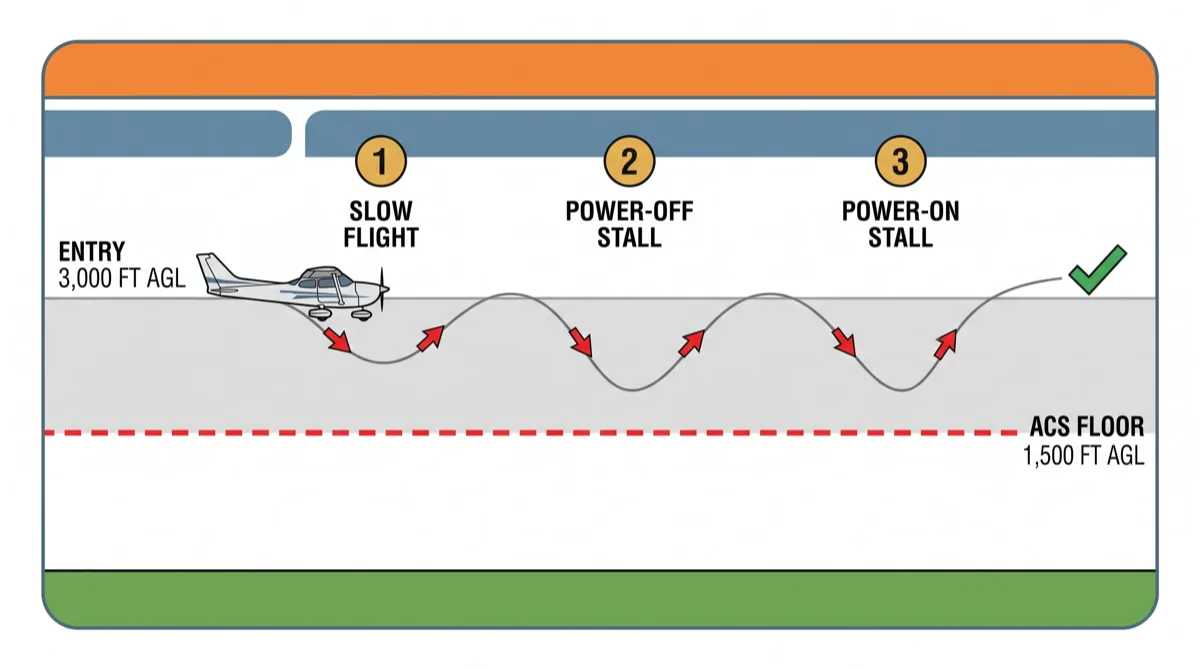
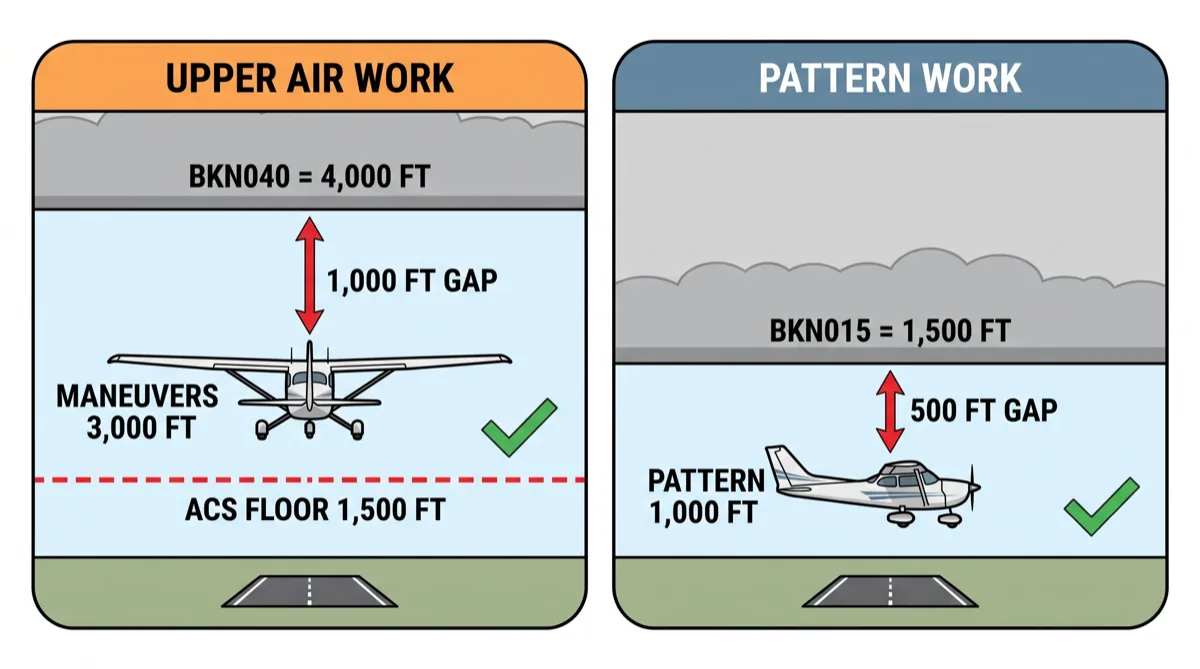
A ceiling has to clear that floor with room to spare: enough to enter the maneuver, work it, and recover, plus the 500 feet of cloud clearance 14 CFR 91.155 already requires below the deck. Upper air work needs more of that room than pattern work does, which is why we use two ceiling numbers instead of one. Our rule of thumb for upper air work is a 4,000 foot ceiling, no lower, and it is a school habit, not an FAA minimum. Pattern work at 1,000 feet AGL needs far less sky above it.
Five lessons, five forecasts, five calls
Every scenario is the same lesson: 3 pm to 5 pm local, New York, in summer, so the block is 19Z to 21Z, flown out of Republic Airport (KFRG), whose runways are 14/32 and 1/19, read from the KISP TAF because Republic has none. The forecasts are training examples written for this guide, dated to a past July, and are not live products. Read the raw line, cover the decoded version, decide, then check.
Scenario 1: the easy yes
TAF KISP 181140Z 1812/1912 21006KT P6SM FEW050
     FM181800 22009KT P6SM SCT060
     FM190100 20005KT P6SM SKC
Decoded for the 19Z to 21Z block: from 18Z the wind is 220 at 9 knots, visibility better than six miles, scattered clouds at 6,000 feet, no ceiling. At Republic that wind favors runway 19, which is 30 degrees off the wind, so the crosswind is about 4 knots. Nothing changes until 01Z, long after you land.
Lesson start:
Lesson end:
Scenario 2: the lid that lifts too late
TAF KISP 181140Z 1812/1912 09008KT 5SM BR BKN012
     FM181500 10008KT P6SM BKN012
     BECMG 1820/1822 12007KT P6SM SCT040
     FM190000 15005KT P6SM FEW250
Decoded for the block: from 15Z the mist clears but the sky stays broken at 1,200 feet, and that 1,200 foot ceiling holds through 20Z. Between 20Z and 22Z it gradually becomes scattered at 4,000. Your block starts at 19Z under a 1,200 foot lid and ends at 21Z while the change is still happening.
Lesson start:
Lesson end:
Scenario 3: the wind day
TAF KISP 181140Z 1812/1912 29018G26KT P6SM SCT045
     FM182200 30014G20KT P6SM FEW050
     FM190300 31008KT P6SM SKC
Decoded for the block: wind from 290 at 18 knots gusting 26, visibility better than six, scattered at 4,500, no ceiling. Ceiling and visibility are fine. The wind is not. Republic's runway 32 is 30 degrees off this wind, so the steady crosswind component is about 9 knots and the gusts push it to 13. Runway 1 is 80 degrees off it and out of the question.
Lesson start:
Lesson end:
Scenario 4: the showers you cannot pin down
TAF KISP 181140Z 1812/1912 17010KT P6SM SCT030 BKN060
     TEMPO 1819/1822 4SM -SHRA BKN020
     FM190000 20008KT P6SM SCT050
Decoded for the block: base weather is wind 170 at 10, visibility better than six, scattered at 3,000 and a ceiling of 6,000 feet, which passes. But between 19Z and 22Z, temporarily, the forecaster expects periods of four miles in light rain showers with a 2,000 foot ceiling, and those hours are your block.
Lesson start:
Lesson end:
Scenario 5: the night-before no
TAF KISP 172340Z 1800/1900 20010KT P6SM SCT040
     FM181500 21012G20KT P6SM SCT035 BKN050
     PROB30 1818/1822 2SM TSRA OVC015CB
     FM190000 25008KT P6SM SCT040
Decoded for the block: from 15Z the wind is 210 at 12 gusting 20 with a 5,000 foot ceiling, which on its own is a marginal but flyable afternoon. Then, between 18Z and 22Z, a 30 percent chance of two miles in a thunderstorm with an overcast at 1,500 feet, and your block sits in the middle of that window.
Lesson start:
Lesson end:
Scenario 1: the easy yes
Checked at 7:45 am on lesson day, the 12Z issue.
TAF KISP 181140Z 1812/1912 21006KT P6SM FEW050
     FM181800 22009KT P6SM SCT060
     FM190100 20005KT P6SM SKC
Decoded for the 19Z to 21Z block: from 18Z the wind is 220 at 9 knots, visibility better than six miles, scattered clouds at 6,000 feet, no ceiling. At Republic that wind favors runway 19, which is 30 degrees off the wind, so the crosswind is about 4 knots. Nothing changes until 01Z, long after you land.
The call: go. Every gate is met with room to spare, and the forecast is quiet on both sides of the block.
Scenario 2: the lid that lifts too late
Checked at 7:45 am on lesson day, the 12Z issue.
TAF KISP 181140Z 1812/1912 09008KT 5SM BR BKN012
     FM181500 10008KT P6SM BKN012
     BECMG 1820/1822 12007KT P6SM SCT040
     FM190000 15005KT P6SM FEW250
Decoded for the block: from 15Z the mist clears but the sky stays broken at 1,200 feet, and that 1,200 foot ceiling holds through 20Z. Between 20Z and 22Z it gradually becomes scattered at 4,000. Your block starts at 19Z under a 1,200 foot lid and ends at 21Z while the change is still happening.
The call: reschedule, later the same day if the schedule allows. A 1,200 foot ceiling fails the 5,000 foot gate and sits below a normal traffic pattern. But the same TAF says the lid is gone by 22Z, which is 6 pm local. Move the lesson to the evening, or to tomorrow, and you have used the forecast instead of fighting it.
Scenario 3: the wind day
Checked at 7:45 am on lesson day, the 12Z issue.
TAF KISP 181140Z 1812/1912 29018G26KT P6SM SCT045
     FM182200 30014G20KT P6SM FEW050
     FM190300 31008KT P6SM SKC
Decoded for the block: wind from 290 at 18 knots gusting 26, visibility better than six, scattered at 4,500, no ceiling. Ceiling and visibility are fine. The wind is not. Republic's runway 32 is 30 degrees off this wind, so the steady crosswind component is about 9 knots and the gusts push it to 13. Runway 1 is 80 degrees off it and out of the question.
The call: no for a solo, and a maybe for a dual lesson. Thirteen knots in gusts is over the 10 knot student gate and near what a Cessna 172 was demonstrated to handle. It is also exactly the day a crosswind lesson is for, with an instructor beside you who can take the airplane. Call your instructor the night before, not at the airport, and let them decide whether today is that lesson.
Scenario 4: the showers you cannot pin down
Checked at 7:45 am on lesson day, the 12Z issue.
TAF KISP 181140Z 1812/1912 17010KT P6SM SCT030 BKN060
     TEMPO 1819/1822 4SM -SHRA BKN020
     FM190000 20008KT P6SM SCT050
Decoded for the block: base weather is wind 170 at 10, visibility better than six, scattered at 3,000 and a ceiling of 6,000 feet, which passes. But between 19Z and 22Z, temporarily, the forecaster expects periods of four miles in light rain showers with a 2,000 foot ceiling, and those hours are your block.
The call: wait for the 18Z amendment, then decide at 1 pm. TEMPO means it might hit you and it might not. The 18Z TAF comes out around 1:40 pm, the 17Z and 18Z METARs will show whether showers are already on the radar, and two hours out is when you make this call. Have the reschedule ready so that a no at 1 pm costs nobody anything.
Scenario 5: the night-before no
Checked at 8:30 pm the night before, the 00Z issue.
TAF KISP 172340Z 1800/1900 20010KT P6SM SCT040
     FM181500 21012G20KT P6SM SCT035 BKN050
     PROB30 1818/1822 2SM TSRA OVC015CB
     FM190000 25008KT P6SM SCT040
Decoded for the block: from 15Z the wind is 210 at 12 gusting 20 with a 5,000 foot ceiling, which on its own is a marginal but flyable afternoon. Then, between 18Z and 22Z, a 30 percent chance of two miles in a thunderstorm with an overcast at 1,500 feet, and your block sits in the middle of that window.
The call: reschedule tonight. A 30 percent chance of a thunderstorm across your lesson hour is a no for a student, and it is a no you know 18 hours in advance. Move the lesson now, free the slot, and spend tomorrow afternoon in a simulator, where the weather is whatever you set it to.
Practice it at home, every week
None of this is learned at the airport. It is learned on the couch, with a phone, three times a week, until reading BKN012 is as fast as reading "cloudy". Two free official sources give you everything above.
- aviationweather.gov is the NOAA Aviation Weather Center. Type a station identifier and you get the METAR and the TAF, raw and decoded, with the map behind them.
- 1800wxbrief.com is Leidos Flight Service, the federally funded briefing service. It is free to every pilot, and a briefing you save there is a record that you did the preflight action the regulation asks for.
The drill: pick the TAF nearest your airport, read it on Tuesday for Friday's lesson time, again Thursday night, again Friday two hours before, and write down your call each time. After a month you will be right more often than you expect, and you will be wrong in ways that teach you something the instructor never had time to.
This is step one
A TAF covers five statute miles of one runway complex. Your lesson leaves the pattern, and a cross-country leaves the county. The next guide in this series runs the full briefing the way a professional does it, in ForeFlight, reading several TAFs side by side to build a picture of the region for your lesson hour rather than one airport's forecast. It starts with the table below, because the first question in an area briefing is which forecasts exist.
| Airport | Identifier | TAF | Length | Read it for |
|---|---|---|---|---|
| Long Island MacArthur | KISP | Yes | 24 hours | Republic (KFRG) |
| Kennedy | KJFK | Yes | 30 hours | Republic (KFRG), the whole western island |
| LaGuardia | KLGA | Yes | 30 hours | The city |
| Westchester County | KHPN | Yes | 24 hours | Westchester and Connecticut fields |
| Teterboro | KTEB | Yes | 30 hours | Essex County (KCDW), Morristown (KMMU) |
| Newark | KEWR | Yes | 30 hours | Essex County (KCDW), Morristown (KMMU) |
| Republic | KFRG | No | Use KISP and KJFK | |
| Essex County | KCDW | No | Use KTEB and KEWR | |
| Morristown | KMMU | No | Use KTEB and KEWR |
Frequently asked questions
What is the difference between a METAR and a TAF?
A METAR is an observation: the weather at one airport right now, updated about once an hour and more often when conditions change. A TAF is a forecast for the same airport written in the same code, covering the next 24 or 30 hours in blocks that begin with FM, BECMG, TEMPO or PROB. You read the METAR two hours before a lesson to see whether the TAF is coming true.
Why are TAFs written in UTC instead of local time?
Airline flights cross time zones, and forecasts, clearances and flight plans all have to mean the same instant at both ends of a flight, so the FAA uses Coordinated Universal Time for all operations. New York is UTC minus four hours in daylight time and minus five in standard time. A 3 pm summer lesson is 19Z; a 3 pm winter lesson is 20Z.
How far ahead can I tell whether my lesson will be cancelled for weather?
NOAA rates a five-day forecast at about 90 percent, but that is for a high temperature and a rain chance, not a ceiling at 3 pm. Three days out you can see whether a system is coming. The night before, the TAF issued around 8 pm gives you the wind, ceiling and visibility for your lesson hour, and that is when a clear no becomes your reschedule, not your instructor's.
What if my airport does not have a TAF?
Use the nearest airport that does and remember it is a forecast for that field, five statute miles around it. Republic Airport (KFRG) has no TAF, so Republic students read Long Island MacArthur (KISP) and Kennedy (KJFK). Essex County and Morristown students read Teterboro (KTEB) and Newark (KEWR). The table above lists the New York area.
What weather should a student pilot cancel for?
For a visual lesson I use four gates: a ceiling of 5,000 feet or higher, visibility of five statute miles or better, a crosswind component under 10 knots, and no rain, snow or thunderstorm anywhere in the lesson block. The legal VFR minimums in 14 CFR 91.155 are lower, but legal is the floor for a licensed pilot, not the target for a lesson.